
Lipis Rocks The Geopark Scene: Pahang MB Announces Certification
From ancient caves to towering mountains, Pahang offers diverse geological landscapes that will captivate any traveller.
Subscribe to our FREE Newsletter, or Telegram and WhatsApp channels for the latest stories and updates.
Pahang’s Lipis district has been officially recognized as the largest National Geopark in Malaysia, according to Datuk Seri Wan Rosdy Wan Ismail, the state’s Menteri Besar.
The Ministry of Natural Resources, Environment and Climate Change acknowledged Lipis as a National Geopark recently during a meeting chaired by its Secretary-General, Dr. Ching Thoo.
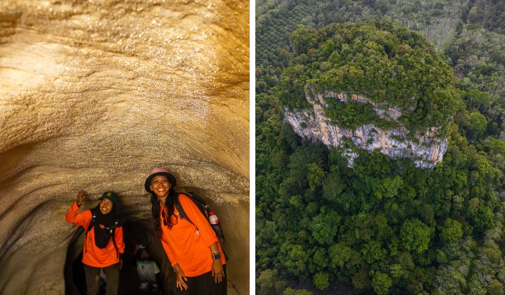
The district, now known as Lipis Geopark, covers an area of 5,198 square kilometres and includes 28 geological heritage sites, 18 cultural heritage sites, and six biological heritage sites.
The Lipis Geopark has designated several noteworthy locations as National Geopark sites.
These include the Lipis Geopark Aspiration Gallery, the National Geosite featuring the Bentong-Raub Suture Zone, Perms-Trias Junction Bama Cave, and Kuala Sungai Lipis.
The Geotourism Value Geosite also encompasses the Tahi Bintang Cave and the Dragon Scale Cave, known locally as Gua Sisik Naga.
The establishment of Lipis Geopark aligns with the Pahang Heritage Destination Blueprint (2024-2028) that seeks to elevate it as a premier destination for UNESCO-branded sites, including World Heritage Sites (WHS), Man and Biosphere Program (MAB), and UNESCO Global Geoparks (UGGp).
Wan Rosdy appreciated all parties involved in making Lipis a National Geopark, particularly the Pahang State Park Corporation (PTNP).
He also hopes that active participation from the local community and stakeholders will put the Lipis Geopark on the right track to be recognized as a UNESCO Global Geopark in 2025.
Unveiling the Mysteries of Malaysia’s Ancient Past: Exploring Lembah Tanum’s Geological Wonders
Lembah Tanum, a part of Lipis, Pahang, is especially rich in geological heritage sites.
The unique geological formations found in Lembah Tanum are believed to be over 250 million years old, providing a glimpse into Malaysia’s ancient history.
The geological formations found in Lembah Tanum are visually striking and hold significant scientific value.
Geologists and researchers are drawn to this region to study the unique rock layers, fossils, and geological structures that provide valuable insights into the Earth’s ancient past.
By carefully examining these formations, scientists can unravel the mysteries of past ecosystems, climate changes, and even the evolution of life on our planet.
Exploring Lembah Tanum’s geological heritage is an awe-inspiring experience that allows visitors to connect with the ancient history of Malaysia.
READ MORE: Unveiling the Hidden Gem of Lembah Tanum: Gua Temalong And Its Enchanting Fig Tree Roots
As you traverse the landscape, you can imagine the dramatic shifts in tectonic plates, the ebb and flow of ancient seas, and the gradual formation of these magnificent geological features.
Whether you are an avid geology enthusiast or simply a curious traveller, Lembah Tanum offers a unique opportunity to witness the grandeur of Malaysia’s geological heritage.
It is a place where time stands still, allowing us to appreciate the immense scale and beauty of our planet’s geological history.
Share your thoughts with us via TRP’s Facebook, Twitter, Instagram, or Threads.
