
Batang Kali Landslide Report: Changing Groundwater Flow And Barrier Lake Identified As Culprits
The report by NADMA emphasises insufficient evidence to attribute blame to human activities.
Subscribe to our FREE Newsletter, or Telegram and WhatsApp channels for the latest stories and updates.
The recently released landslide report by the National Disaster Management Agency (NADMA) regarding the Batang Kali incident confirms that there were two main causes.
Firstly, heavy rainfall and mudslides resulted in the deposition of approximately 280,000 cubic meters of land, forming a barrier lake.
This alteration in groundwater flow direction ultimately led to the tragic landslide at the camp.
The report emphasizes that no evidence indicates human factors cause the landslide.
While human activities may impact slope stability, it cannot be proven that human factors played a significant role in this incident.
Slope roads are maintained on schedule
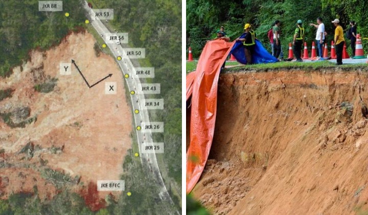
The report states that the first landslide occurred at 2 a.m., covering an area of 120 meters along the slope with a depth of 14 meters.
Following the initial landslide, a debris flow rushed towards the camping site located approximately 550 meters away from the landslide site.
As the debris flow moved towards the camp, it carried dirt, stones, trees, and other debris piled up on the hillside, forming a 28-meter-high barrier lake holding around 3,000 cubic meters of water.
The report also clarifies that there was no large-scale excavation work in the camp before the incident.
Additionally, the investigation report highlights that maintenance and repair work on slopes and roads near the landslide site was conducted according to schedule.
The public can access the full report of the Landslide Working Group Committee (JKKTR) through the NADMA website at https://www.nadma.gov.my.
Harnessing AI and Extending Plans: Key Recommendations from the Report
The report provides five recommendations, including using advanced artificial intelligence (AI) for big data analysis.
The report suggests that big data analysis can effectively manage slope data, providing decision-making references at all levels.
Additionally, the report recommends that authorities enforce ordinances and guidelines for camping and recreation areas to reduce the risk of similar accidents occurring in the future.
Mitigation and prevention measures should be implemented for federal and state highways, including implementing slope hazard and risk maps.
The report further suggests that routine inspections and maintenance of road assets should be conducted regularly to minimize risks.
🚧 #teamroadcare 🚧
— Roadcare LipisCH (@RC_LipisCh) October 19, 2023
Kerja penyelenggaraan kecemasan pemasangan plastic sheeting di kawasan tanah runtuh di FT102 Seksyen 28.30, Jalan Pos Betau – Lembah Bertam, Daerah Cameron Highlands, Pahang Darul Makmur.@JKRPAHANG @jkrchighlands@Roadcare_HQ @Roadcare_Phg @RcBentong pic.twitter.com/KKnHNKSoZG
To strengthen effective slope management programs and reduce the risk of loss of life and property, the National Slopes Master Plan 2009-2023 should be extended by 15 years due to ongoing climate change and hazards.
Finally, the report recommends devolving authority to officials from the Slope Engineering Branch to lead all landslide investigations.
The devastating landslide at Father’s Organic Farm in Batang Kali occurred on 16 December the previous year, profoundly impacting the nation.
The incident involved 92 individuals, with 61 being successfully rescued, but tragically, 31 lives were lost, including 13 primary school students.
READ MORE: Father’s Organic Farm Expresses Sympathy And Condolence, Says Natural Disasters Are Inevitable
‼️BREAKING‼️
— Rachel Tsen (@tsen_rachel) December 30, 2022
LAST LANDSLIDE VICTIM IDENTIFIED
On December 25th 2022, the last victim at Father's Organic Farm campsite in Gohtong Jaya, Batang Kali, founded by The National Disaster Management Agency (Nadma).
Read more about it here: https://t.co/Fx2ttyGoLf
What is a barrier lake?
Barrier lakes can be created through various natural processes.
For instance, when volcanic lava flows, glacial moraines, earthquakes, or landslides occur and collapse rocks, valleys or river beds, they can become blocked, causing water to be trapped and forming a barrier lake.
Additionally, when earthquakes or landslides cause collapses on both sides of a river, and the resulting debris obstructs the river, a barrier lake is also formed.
The formation of a barrier lake typically involves four steps: first, there is a pre-existing water system; second, something blocks the water system; third, the blocked valleys or river beds cause the water to overflow in all directions; fourth, the water accumulates to a certain level.
When a barrier lake bursts, it can result in debris flow disasters downstream.
Share your thoughts with us via TRP’s Facebook, Twitter, Instagram, or Threads.
